India's weather pattern is undergoing a major shift as the southwest monsoon continues its steady advance across the country. After arriving in Kerala earlier than expected, the monsoon has now progressed further into parts of the Arabian Sea, Maharashtra, Karnataka, Andhra Pradesh, and Telangana. Meanwhile, the India Meteorological Department (IMD) has revealed a fresh timeline for the monsoon's arrival in West Bengal and issued a widespread heavy rainfall alert for multiple regions over the next seven days.
According to the latest weather forecasts, several states are likely to witness intense rainfall activity, while a new western disturbance is expected to bring dramatic changes to weather conditions across northern India later this week.
Monsoon Likely to Enter West Bengal Within Days
The IMD's regional meteorological center in Kolkata has indicated that the southwest monsoon is expected to reach the sub-Himalayan districts of West Bengal within the next three to four days.
Although the monsoon is running slightly behind its usual arrival date in the state, meteorologists say atmospheric conditions remain favorable for its further advancement. Even before the official onset, several districts in North Bengal have already been experiencing significant pre-monsoon showers.
Heavy to very heavy rainfall is forecast over districts such as:
-
Darjeeling
-
Kalimpong
-
Jalpaiguri
-
Alipurduar
-
Cooch Behar
Weather officials expect these areas to continue receiving substantial rainfall over the next couple of days as moisture-laden winds strengthen across eastern India.
North Bengal Records Intense Rainfall
Several districts in North Bengal have already witnessed notable rainfall activity.
Alipurduar, located near the Assam border, recorded the highest rainfall in the state, receiving around 133 mm of precipitation in a 24-hour period ending Monday morning.
Other rainfall figures reported include:
-
Jalpaiguri: 53 mm
-
Kalimpong: 19 mm
-
Cooch Behar: 18 mm
-
Darjeeling: 7.8 mm
While rainfall has also occurred in parts of South Bengal, weather conditions remain humid and uncomfortable in many areas. The IMD expects light to moderate showers to continue across southern districts over the next two days.
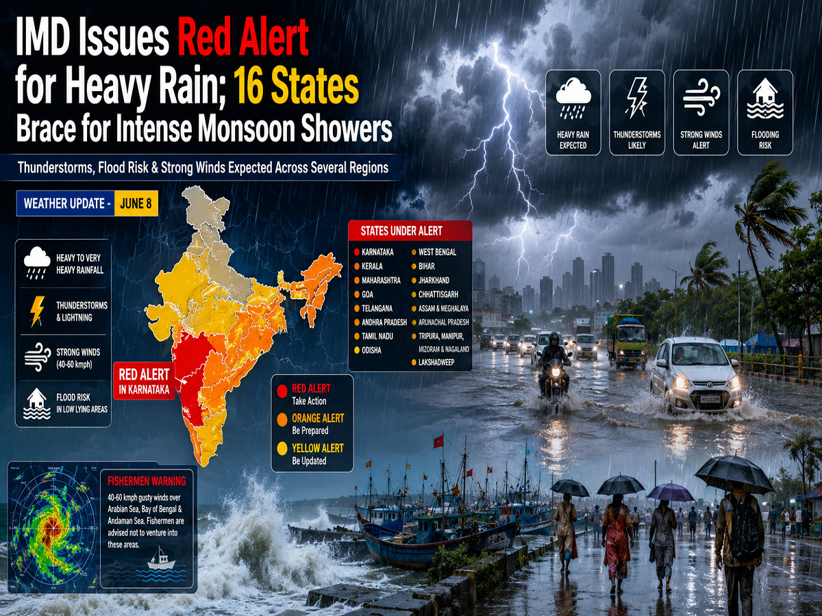
IMD Warns of Heavy to Extremely Heavy Rainfall
The weather department has issued a major rainfall advisory for several parts of the country. According to the latest bulletin, many regions could receive between 7 cm and 20 cm of rainfall during the next week.
Particularly intense rainfall is expected in:
-
Kerala
-
Coastal Karnataka
-
Interior Karnataka
-
Tamil Nadu
-
Sub-Himalayan West Bengal
-
Sikkim
-
Northeastern states
Kerala and Karnataka may witness isolated episodes of extremely heavy rainfall on June 8 and June 9, raising concerns about waterlogging, localized flooding, and transportation disruptions.
The entire northeastern region is also likely to remain under the influence of persistent monsoon activity, resulting in widespread rainfall throughout the week.
Major Weather Change Expected in North India
While southern and eastern India prepare for heavy rainfall, northern India is currently experiencing rising temperatures and heatwave conditions.
The IMD expects temperatures across northwestern India to increase by 2°C to 4°C until June 11. Regions likely to experience hot weather include:
-
Delhi-NCR
-
Punjab
-
Haryana
-
Rajasthan
-
Uttar Pradesh
However, a fresh western disturbance is expected to become active around June 11, bringing a sharp change in weather conditions.
Thunderstorms, Rain and Hail Forecast for June 11-12
Meteorologists have warned that the approaching western disturbance could trigger widespread thunderstorms, rainfall, and hailstorms across several northern states.
Heavy hail activity is possible in:
-
Himachal Pradesh
-
Uttarakhand
-
Jammu & Kashmir
In addition, Delhi, Haryana, and Chandigarh may also witness hailstorms on June 12.
Strong winds ranging from 50 to 60 kmph, accompanied by lightning and moderate rainfall, are expected across Delhi, Punjab, Haryana, Rajasthan, and Uttar Pradesh between June 11 and June 12.
Following this weather system, temperatures across northwestern India could drop by 3°C to 5°C, bringing significant relief from the ongoing heat.
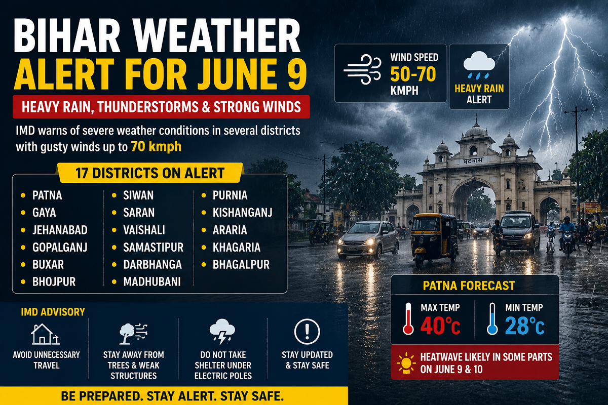
Rain and Storm Alert for Bihar, Jharkhand and Central India
Eastern and central parts of the country are also expected to see active weather conditions in the coming days.
The IMD has forecast heavy rainfall in Bihar between June 10 and June 12. During the same period, Bihar, Jharkhand, and Gangetic West Bengal may experience strong thunderstorms accompanied by gusty winds reaching speeds of 50-60 kmph.
Meanwhile, scattered rainfall and thunderstorm activity are likely to continue across:
-
Madhya Pradesh
-
Chhattisgarh
-
Vidarbha region
Chhattisgarh, in particular, has been placed under a thunderstorm alert for June 11 and June 12 due to the possibility of powerful winds and lightning activity.
Outlook for the Week Ahead
The coming week is expected to bring contrasting weather conditions across India. While southern, eastern, and northeastern states prepare for heavy monsoon rains, northern India will witness a transition from intense heat to thunderstorms and cooler temperatures.
With the monsoon advancing steadily and multiple weather systems becoming active simultaneously, residents in affected regions are advised to monitor official weather updates and take necessary precautions against heavy rainfall, strong winds, and possible flooding.